
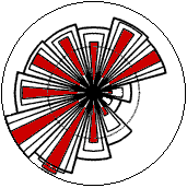
![]() Wind
rose from Brest, France, taken from the European Wind Atlas,
Risø National Laboratory, Denmark.
Wind
rose from Brest, France, taken from the European Wind Atlas,
Risø National Laboratory, Denmark.
The Wind Rose
![]()
![]() You
will notice that strong winds usually come from a particular
direction, as discussed in the Wind Energy
Resource section.
You
will notice that strong winds usually come from a particular
direction, as discussed in the Wind Energy
Resource section.
![]() To show the information about the distributions
of wind speeds, and the frequency of the varying wind directions,
one may draw a so-called wind rose on the basis of meteorological
observations of wind speeds and wind directions.
To show the information about the distributions
of wind speeds, and the frequency of the varying wind directions,
one may draw a so-called wind rose on the basis of meteorological
observations of wind speeds and wind directions.
![]() The picture shows the wind rose for Brest,
on the Atlantic coast of France.
The picture shows the wind rose for Brest,
on the Atlantic coast of France.
![]() We have divided the compass into 12 sectors,
one for each 30 degrees of the horizon. (A wind rose may also
be drawn for 8 or 16 sectors, but 12 sectors tend to be the standard
set by the European Wind Atlas, from which this image was taken).
We have divided the compass into 12 sectors,
one for each 30 degrees of the horizon. (A wind rose may also
be drawn for 8 or 16 sectors, but 12 sectors tend to be the standard
set by the European Wind Atlas, from which this image was taken).
![]() The radius of the 12 outermost, wide wedges
gives the relative frequency of each of the 12 wind directions,
i.e. how many per cent of the time is the wind blowing from that
direction.
The radius of the 12 outermost, wide wedges
gives the relative frequency of each of the 12 wind directions,
i.e. how many per cent of the time is the wind blowing from that
direction.
![]() The second wedge gives the same information,
but multiplied by the average wind speed in each particular direction.
The result is then normalised to add up to 100 per cent. This
tells you how much each sector contributes to the average wind
speed at our particular location.
The second wedge gives the same information,
but multiplied by the average wind speed in each particular direction.
The result is then normalised to add up to 100 per cent. This
tells you how much each sector contributes to the average wind
speed at our particular location.
![]() The innermost (red) wedge gives the same
information as the first, but multiplied by the cube of the wind
speed in each particular location. The result is then normalised
to add up to 100 per cent. This tells you how much each sector
contributes to the energy content of the wind at our particular
location.
The innermost (red) wedge gives the same
information as the first, but multiplied by the cube of the wind
speed in each particular location. The result is then normalised
to add up to 100 per cent. This tells you how much each sector
contributes to the energy content of the wind at our particular
location.
![]() Remember, that the energy content of the
wind varies with the cube of the wind speed, as we discussed
in the page on The Energy in the Wind.
So the red wedges are really the most interesting ones. They
tell us where to find the most power to drive our wind turbines.
Remember, that the energy content of the
wind varies with the cube of the wind speed, as we discussed
in the page on The Energy in the Wind.
So the red wedges are really the most interesting ones. They
tell us where to find the most power to drive our wind turbines.
![]() In this case we can see that the prevailing
wind direction is Southwest, just as we would have predicted
from the page on Global Winds.
In this case we can see that the prevailing
wind direction is Southwest, just as we would have predicted
from the page on Global Winds.
![]() A wind rose gives you information on the
relative wind speeds in different directions, i.e.each
of the three sets of data (frequency, mean wind speed, and mean
cube of wind speed) has been multiplied by a number which ensures
that the largest wedge in the set exactly matches the radius
of the outermost circle in the diagram.
A wind rose gives you information on the
relative wind speeds in different directions, i.e.each
of the three sets of data (frequency, mean wind speed, and mean
cube of wind speed) has been multiplied by a number which ensures
that the largest wedge in the set exactly matches the radius
of the outermost circle in the diagram.
Wind
Roses Vary
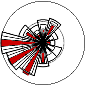
![]() Wind
roses vary from one location to the next. They actually are a
form of meteorological fingerprint.
Wind
roses vary from one location to the next. They actually are a
form of meteorological fingerprint.
![]() As an example, take a look at this wind rose
from Caen, France, only about 150 km (100 miles) North of Brest.
Although the primary wind direction is the same, Southwest, you
will notice that practically all of the wind energy comes from
West and Southwest, so on this site we need not concern ourselves
very much about other wind directions.
As an example, take a look at this wind rose
from Caen, France, only about 150 km (100 miles) North of Brest.
Although the primary wind direction is the same, Southwest, you
will notice that practically all of the wind energy comes from
West and Southwest, so on this site we need not concern ourselves
very much about other wind directions.
![]() Wind roses from neighbouring areas are often
fairly similar, so in practice it may sometimes be safe to interpolate
(take an average) of the wind roses from surrounding observations.
If you have complex terrain, i.e. mountains and valleys running
in different directions, or coastlines facing in different directions,
it is generally not safe to make simple assumptions like
these.
Wind roses from neighbouring areas are often
fairly similar, so in practice it may sometimes be safe to interpolate
(take an average) of the wind roses from surrounding observations.
If you have complex terrain, i.e. mountains and valleys running
in different directions, or coastlines facing in different directions,
it is generally not safe to make simple assumptions like
these.
![]() The wind rose, once again, only tells you
the relative distribution of wind directions, not the
actual level of the mean wind speed.
The wind rose, once again, only tells you
the relative distribution of wind directions, not the
actual level of the mean wind speed.
How
to Use the Wind Rose
A look at the wind rose is extremely useful for siting wind turbines.
If a large share of the energy in the wind comes from a particular
direction, then you will want to have as few obstacles
as possible, and as smooth a terrain as possible in that direction,
when you place wind turbines in the landscape.
![]() In these examples most of the energy comes
from the Southwest. We therefore need not be very concerned about
obstacles to the East or Southeast of wind turbines, since practically
no wind energy would come from those directions.
In these examples most of the energy comes
from the Southwest. We therefore need not be very concerned about
obstacles to the East or Southeast of wind turbines, since practically
no wind energy would come from those directions.
![]() You should note, however, that wind patterns
may vary from year to year, and the energy content may vary (typically
by some ten per cent) from year to year, so it is best to have
observations from several years to make a credible average. Planners
of large wind parks will usually rely on one year of local measurements,
and then use long-term meteorological observations from nearby
weather stations to adjust their measurements to obtain a reliable
long term average.
You should note, however, that wind patterns
may vary from year to year, and the energy content may vary (typically
by some ten per cent) from year to year, so it is best to have
observations from several years to make a credible average. Planners
of large wind parks will usually rely on one year of local measurements,
and then use long-term meteorological observations from nearby
weather stations to adjust their measurements to obtain a reliable
long term average.
![]() Since this wind rose comes from the European
Wind Atlas we are reasonably confident that we can rely on it.
The European Wind Atlas contains a description of each of the
measurement stations, so we may be warned about possible local
disturbances to the airflow. On the page on selecting a wind
turbine site, we return to the pitfalls
in using meteorology data.
Since this wind rose comes from the European
Wind Atlas we are reasonably confident that we can rely on it.
The European Wind Atlas contains a description of each of the
measurement stations, so we may be warned about possible local
disturbances to the airflow. On the page on selecting a wind
turbine site, we return to the pitfalls
in using meteorology data.
![]()
| Back | Home
| Forward |
© Copyright 2000 Soren Krohn.
All rights reserved.
Updated 6 August 2000
http://www.windpower.org/tour/wres/rose.htm